2020 - Exploring the limits of ensemble forecasting via solutions of the Liouville equation for realistic geophysical models
Hermoso, A., Homar, V., and Yano, J. I.
DOI: 10.1016/j.atmosres.2020.105127
IF: 4,676 - Q1 (2019)

The atmosphere is an exemplary case of uncertain system. The state of such systems is described by means of probability density functions which encompass uncertainty information. In this regard, the Liouville equation is the theoretical framework to predict the evolution of the state of uncertain systems. This study analyses the morphological characteristics of the time evolution of probability density functions for some low complexity geophysical systems by solving the Liouville equation in order to obtain tractable solutions which are otherwise unfeasible with currently available computational resources. The current and usual modest approach to overcome these obstacles and estimate the probability density function of the system in realistic weather and climate applications is the use of a discrete and small number of samples of the state of the system, evolved individually in a deterministic, perhaps sometimes stochastic, way. We investigate particular solutions of the shallow water equations and the barotropic model that allow to apply the Liouville formalism to explore its topological characteristics and interpret them in terms of the ensemble prediction system approach. We provide quantitative evidences of the high variability that solutions to Liouville equation may present, challenging currently accepted uses and interpretations of ensemble forecasts.
Citation:
2020 - Diagnosis of a high-impact secondary cyclone during HyMeX-SOP1 IOP18
Carrió, D.S., Homar, V., Jansà, A., Picornell, M.A., and Campins, J.
DOI: 10.1016/j.atmosres.2020.104983
IF: 4,676 - Q1 (2019)
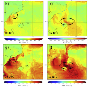
Multiple high-impact weather events occurred during HyMeX-SOP1, which was intensively monitored by a large number of ordinary and extraordinary observations. The availability of special observations offers an unprecedented opportunity to explore these events in depth and assess the capabilities of current numerical weather prediction tools. In this case, a small-scale secondary cyclone formed within a prominent cyclone that intensified in the north-western part of the western Mediterranean during IOP18 on October 31, 2012. The small secondary system formed near Catalonia, where heavy rain was observed, and then moved to the northern part of the island of Minorca, producing very strong winds. Finally, the secondary cyclone moved northeast while merging with the main cyclone and evolving as a cyclonic perturbation towards the Gulf of Genoa, bringing heavy precipitation to some Italian regions.
This work aims at providing a detailed diagnosis of the genesis and evolution of the secondary cyclone, using high-resolution numerical tools. Furthermore, with the main objective of identifying the main physical mechanisms involved in the genesis and evolution of the small-scale secondary cyclone, sensitivity experiments were performed taking into account three main factors: latent heat release, upper-level dynamical forcing and topographical effects. Results show that in terms of individual cyclogenetic contributions, the upper level PV anomaly contribution dominated the initial phase and the diabatic heating from condensation contributed to the further deepening during the later stages of the secondary cyclone. The initial dynamical effect from the upper-levels forcing was amplified by the local topographic features, becoming a key synergistic factor for the formation of the damaging secondary cyclonic system.
Citation:
2020 - Precipitation features of the maritime continent in parameterized and explicit convection models
Argüeso, D., Romero, R., and Homar, V.
DOI: 10.1175/JCLI-D-19-0416.s1.
IF: 5,707 - Q1 (2019)
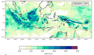
The Maritime Continent is the largest archipelago in the world and a region of intense convective activity that influences Earth’s general circulation. The region features one of the warmest oceans, very complex topography, dense vegetation, and an intricate configuration of islands, which together result in very specific precipitation characteristics, such as a marked diurnal cycle. Atmospheric models poorly resolve deep convection processes that generate rainfall in the archipelago and show fundamental errors in simulating precipitation. Spatial resolution and the use of convective schemes required to represent subgrid convective circulations have been pointed out as culprits of these errors. However, models running at the kilometer scale explicitly resolve most convective systems and thus are expected to contribute to solve the challenge of accurately simulating rainfall in the Maritime Continent. Here we investigate the differences in simulated precipitation characteristics for different representations of convection, including parameterized and explicit, and at various spatial resolutions. We also explore the vertical structure of the atmosphere in search of physical mechanisms that explain the main differences identified in the rainfall fields across model experiments. Our results indicate that both increased resolution and representing convection explicitly are required to produce a more realistic simulation of precipitation features, such as a correct diurnal cycle both over land and ocean. We found that the structures of deep and shallow clouds are the main differences across experiments and thus they are responsible for differences in the timing and spatial distribution of rainfall patterns in the various convection representation experiments.
Citation:
2020 - Validation of the AROME, ALADIN and WRF meteorological models for flood forecasting in Morocco
El Khalki, E. M., Tramblay, Y., Amengual, A., Homar, V., Romero, R., Saidi, M. E. M., and Alaouri, M.
DOI: 10.3390/w12020437
IF: 2.544 - Q2 (2019)
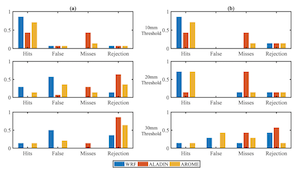
Flash floods are common in small Mediterranean watersheds and the alerts provided by real-time monitoring systems provide too short anticipation times to warn the population. In this context, there is a strong need to develop flood forecasting systems in particular for developing countries such as Morocco where floods have severe socio-economic impacts. In this study, the AROME (Application of Research to Operations at Mesoscale), ALADIN (Aire Limited Dynamic Adaptation International Development) and WRF (Weather Research and Forecasting) meteorological models are evaluated to forecast flood events in the Rheraya and Ourika basin located in the High-Atlas Mountains of Morocco. The model evaluation is performed by comparing for a set of flood events the observed and simulated probabilities of exceedances for different precipitation thresholds. In addition, two different flood forecasting approaches are compared: the first one relies on the coupling of meteorological forecasts with a hydrological model and the second one is a based on a linear relationship between event rainfall, antecedent soil moisture and runoff. Three different soil moisture products (in-situ measurements, European Space Agency’s Climate Change Initiative ESA-CCI remote sensing data and ERA5 reanalysis) are compared to estimate the initial soil moisture conditions before flood events for both methods. Results showed that the WRF and AROME models better simulate precipitation amounts compared to ALADIN, indicating the added value of convection-permitting models. The regression-based flood forecasting method outperforms the hydrological model-based approach, and the maximum discharge is better reproduced when using the WRF forecasts in combination with ERA5. These results provide insights to implement robust flood forecasting approaches in the context of data scarcity that could be valuable for developing countries such as Morocco and other North African countries.
Citation:
2019 - Hydro-meteorological reconstruction and geomorphological impact assessment of the October 2018 catastrophic flash flood at Sant Llorenç, Mallorca (Spain)
Lorenzo-Lacruz, J., Amengual, A., Garcia, C., Morán-Tejeda, E., Homar, V., Maimó-Far, A., Hermoso, A., Ramis, C., and Romero, R.
DOI: 10.5194/nhess-19-2597-2019
IF: 3,102 - Q1
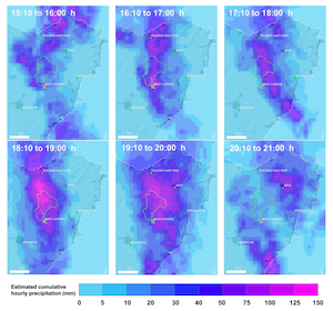
An extraordinary convective rainfall event, unforeseen by most numerical weather prediction models, generated a devastating flash flood (305 m3 s−1) in the town of Sant Llorenç des Cardassar, Mallorca, on 9 October 2018. Four people died inside this village, while casualties were up to 13 over the entire affected area. This extreme event has been reconstructed by implementing an integrated flash flood modelling approach in the Ses Planes catchment up to Sant Llorenç (23.4 km2 ), based on three components: (i) generation of radar-derived precipitation estimates, (ii) modelling of accurate discharge hydrographs yielded by the catchment (using FEST and KLEM models), and (iii) hydraulic simulation of the event and mapping of affected areas (using HEC-RAS). Radar-derived rainfall estimates show very high agreement with rain gauge data (R2 = 0.98). Modelled flooding extent is in close agreement with the observed extension by the Copernicus Emergency Management Service, based on Sentinel-1 imagery, and both far exceed the extension for a 500-year return period flood. Hydraulic simulation revealed that water reached a depth of 3 m at some points, and modelled water depths highly correlate (R2 = 0.91) with in situ after-event measurements. The 9 October flash flood eroded and transported woody and abundant sediment debris, changing channel geomorphology. Water velocity greatly increased at bridge locations crossing the river channel, especially at those closer to the Sant Llorenç town centre. This study highlights how the very low predictability of this type of extreme convective rainfall events and the very short hydrological response times typical of small Mediterranean catchments continue to challenge the implementation of early warning systems, which effectively reduce people’s exposure to flash flood risk in the region.
Citation:
2019 - A quantile–quantile adjustment of the EURO-CORDEX projections for temperatures and precipitation
Cardell, M. F., Romero, R., Amengual, A., Homar, V., and Ramis, C.
DOI: 10.1002/joc.5991
IF: 3.928 - Q1
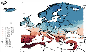
Projections of climate change impacts over Europe are derived using a new quantile–quantile adjustment method. E-OBS high-resolution gridded data sets of daily observed precipitation and 2-m surface minimum and maximum temperatures have been used as the current climate baseline. For projections, the same meteorological variables have been obtained from a set of regional climate models (RCMs) integrated in the EURO-CORDEX project, and by considering the RCP4.5 and RCP8.5 future emissions scenarios. To enhance the reliability of RCM data at local scale, new developments of a previous quantile–quantile adjustment have been applied to the simulated regional scenarios. This method focuses not only on the bulk spectrum of the cumulative distribution functions but also on its tails. Results show an overall improvement in reproducing the present climate baseline when using calibrated series instead of raw RCM outputs. Next, we have used these locally adjusted series to quantify the climate change signal through a number of annual and seasonal indicators. A significant increase of the minimum and maximum temperatures in all seasons is projected over Europe, being more marked in the Mediterranean for summer and autumn. Prospects on future seasonal and annual changes in precipitation are more diverse, showing an overall decrease in southern Europe and the Mediterranean, while precipitation is expected to increase towards the north of the continent. With these sources of information at hand, including and accounting for the identification of the most vulnerable geographical areas, policy makers and stakeholders can respond more effectively to the future challenges imposed by climate change.
Citation:
2019 - Potential of an EnKF Storm-Scale Data Assimilation System Over Sparse Observation Regions with Complex Orography
Carrió, D. S., Homar, V., & Wheatley, D. M.
DOI: 10.1016/j.atmosres.2018.10.004
IF: 4.676 - Q1
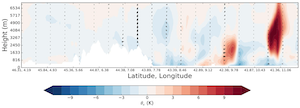
High-impact weather events over sparse data regions with complex orography, such as the Mediterranean region, remain a challenge for numerical weather prediction. This study evaluates, for the first time, the ability of a multiscale ensemble-based data assimilation system to reproduce a heavy precipitation episode that occurred during the first Special Observation Period (SOP1) of the Hydrological cycle in the Mediterranean Experiment (HyMeX). During the Intense Observation Period (IOP13) from 14 to 15 October 2012, convective maritime activity associated with an advancing cold front affected coastal areas of southern France, Corsica and Italy. With the main objective of improving forecasts of this weather event, a data assimilation (DA) system using the Ensemble Kalman Filter (EnKF) algorithm is implemented. The potential impact of assimilating conventional in-situ observations (METAR, aircrafts, buoys and rawinsondes) and single-Doppler reflectivity data to improve numerical representation of growing convective maritime structures that will evolve towards coastal populated areas is evaluated. Results indicate that information provided by both observation sources contribute to initiation and subsequent evolution of convective structures not captured by the conventional runs. Notably, data assimilation experiments produce the best quantitative verification scores for the short range (6–8 h) forecasts of accumulated precipitation. Beyond 6–8 h, data assimilation experiments and those without data assimilation are indistinguishable. Sensitivity experiments, evaluating the impact of increasing the length of the radar data assimilation period, reveal the importance of assimilating high-frequency reflectivity data during a mid-term period (6 h approx.) to better depict deep convective structures initiated over the sea that evolve towards populated coastal areas.
Citation:
2018 - Reviews and perspectives of high impact atmospheric processes in the Mediterranean
Michaelides, S., Karacostas, T., Sánchez, J.L., Retalis, A., Pytharoulis, I., Homar, V., Romero, R., Zanis, P., Giannakopoulos, C., Bühl, J., Ansmann, A., Merino, A., Melcón, P., Lagouvardos, K., Kotroni, V., Bruggeman, A., López-Moreno, J.I., Berthet, C., Katragkou, E., Tymvios, F., Hadjimitsis, D.G., Mamouri, R., Nisantzi, A.
DOI: 10.1016/j.atmosres.2017.11.022
IF: 4.114 - Q1
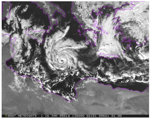
The Mediterranean region is a unique area characterized by a large spectrum of atmospheric phenomena, some of which have a high impact on many aspects of human activities, safety and wellbeing. The area is long considered as a hot spot of such atmospheric phenomena deserving multidisciplinary scientific attention. The scientific research that has been carried out on these high impact atmospheric processes that occur in the Mediterranean area is indeed widespread and the available international literature is very extensive. The paper touches initially the temperature and precipitation regimes, followed by a discussion of floods and droughts. The exciting cyclogenetic patterns of explosive cyclones and medicanes are presented in separate sections. The lightning activity and the presence of dust and other pollutants are also presented herein. The atmospheric chemistry of the region which is increasingly becoming of utmost importance for the area under study is distinctly discussed. Attempts to modify the weather (the precipitation, in particular) are outlined too. The effects of climatic change on various atmospheric processes are considered throughout this paper, in addition to a dedicated section on temperature and precipitation.
Citation:
2017 - PREGRIDBAL 1.0: Towards a high-resolution rainfall atlas for the Balearic Islands (1950-2009)
López, T., Homar, V., Ramis, C., Guijarro, J.A.
DOI: 10.5194/nhess-17-1061-2017
IF: 2.281 - Q1
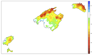
This work presents a catalog of daily precipitation fields in the Balearic Islands created with data from AEMET (State Meteorological Agency) assistant observations, including records from 1912. The original digital daily data file has been interpolated onto a regular 100m-resolution grid (namely PREGRIDBAL), defined with the aim of becoming a valid standard for future methodological improvements and catalog upgrades. Daily precipitation amounts on each grid point are calculated using an analysis method based on ordinary kriging, using the daily anomaly with respect to the annual mean for all available observations each day. Due to quality concerns, the time span for products derived from the catalog is limited to the 1950-2009 period, when the number of operating stations reached 200. Therefore, from the time series of daily maps, monthly-, annual-, quinquennial-, and decadal-accumulations are produced. Similarly, the catalog allowed for quantification of climate trends in rainfall amounts in the Balearic Islands, with the significant advantage of minimizing the biases originated from heterogeneities in the spatial distribution of stations across the archipelago. Results show a general decrease in precipitation during the 1950-2009 period. From 1950 to 1979, the average annual precipitation across the islands was 624.3mm, while from 1980 to 2009 it diminished to 555.36mm. Changes in precipitation patterns, which vary among the different areas, are also detected. The most significant reductions are found in the northern half of the archipelago and especially in Mallorca, where the Tramuntana mountain range stands out. All seasonal trends show a decrease, with values ranging between 1 and 3mmdecade-1, with the exception of autumn, which reaches a positive trend up to 7mmdecade-1. October shows the most dramatic decrease (-10. 34mmdecade-1) and, conversely, September and November show an increase in precipitation (3.28 and 1.82mmdecade-1, respectively) with a statistical significance above 85% across almost the entire archipelago, and even exceeding 95% in Eivissa and Formentera.
Citation:
2017 - Extension of summer climatic conditions into spring in the Western Mediterranean area
Jansa, A., Homar, V., Romero, R., Alonso, S., Guijarro, J.A., Ramis, C.
DOI: 10.1002/joc.4824
IF: 3.1 - Q2
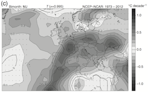
From a local point of view, in May/June, there is an important and positive 2 m temperature trend at Palma (Mallorca), which is simultaneous and highly correlated with a strong increase in the 500 hPa geopotential height. This study analyses this fact as well as the observed tendencies in a wider seasonal and geographical context. We confirm the particularly high correlation between 2 m temperature and 500 hPa geopotential during the warm months as opposed to the much weaker correlation in winter. This suggests that mechanisms for thermal changes act differently throughout the year in this region. Besides the direct radiative effect, warm season near-surface temperatures are linked to the presence of deep anticyclones, which effectively determine the northern edge of the Hadley cell. Accordingly, the strong warming trend in the area of Palma during the warm months of the year is purportedly related to the poleward extension of the Hadley cell. The fact that May/June shows the highest low-level temperature trend among all bi-monthly series is a common regional feature over a relatively wide area over the Western Mediterranean. Different geographical patterns emerge in other periods of the year. In July/August, the strongest low-level warming area drifts to the east-northeast, towards Ukraine and Russia. Coincidentally, the 500 hPa geopotential tendencies show a coherent pattern, with an intense positive trend ridge over the Western Mediterranean area in May/June, and a displacement of this ridge to the north-east in July/August. We show the connection between 500 hPa geopotential height and near-surface temperature by means of a multiple lineal regression that attributes half of the local temperature tendency in Palma to the intensification of a 500 hPa ridge centred over the Western Mediterranean and surroundings.
Citation:
2017 - Losing water in temporary streams on a Mediterranean island: Effects of climate and land-cover changes
Garcia, C., Amengual, A., Homar, V., Zamora, A.
DOI: 10.1016/j.gloplacha.2016.11.010
IF: 3.982 - Q1
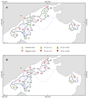
Temporary streams are unique, sensitive and threatened fluvial systems. They periodically dry up and contribute to biodiversity by supporting different species. In Mediterranean regions, human pressures and climate change increase the duration of the dry period for the streams. We analysed the annual and seasonal trends on streamflow data from 14 gauging stations on temporary streams on the island of Mallorca. We used a Mann–Kendall trend test on data from 1977 to 2009 (33 years) to identify trends in discharge, number of days with water, accumulated precipitation, potential evapotranspiration (PET), and land cover change. Results show a general decreasing trend of streamflow during spring and summer, with flows reduced between 4 and 17% in some basins. Although the inter-annual variability is high for both seasons, the decrease in annual precipitation, the increase in temperature, and the effects of colonization and growth of forests explain the reduction in the number of days with running water. Correlation and elasticity analyses show that precipitation is the main driver for streamflow reduction, but the increase in temperature and land-cover changes also play a significant role in the decreasing of flows. These seasonal changes especially affect the headwaters of the basins, which are located in a mountainous area. The Kendall regional test, applied to the 12 basins considered in the Tramuntana range, reveals a significant decreasing annual trend in the number of days with measured flow. The forest expansion and the warmer conditions cause a higher vegetation water demand, increasing the real evapotranspiration and, consequently, reducing the runoff and thus increasing the losses in the water balance. In addition, the increase in the number of days during which channels and parafluvial habitats are disconnected negatively affects the aquatic habitat. This paper provides the first evidence of a consistent long-term reduction in flow in temporary streams in the Mediterranean region. We highlight the ecological implications of losing water in temporary streams across Mallorca, and we argue the urgent need for conservation plans to protect them from present and future changes and challenges.
Citation:
2017 - A comparison of ensemble strategies for flash flood forecasting: The 12 October 2007 case study in Valencia, Spain
Amengual, A., Carrió, D.S., Ravazzani, G., Homar, V.
DOI: 10.1175/JHM-D-16-0281.1
IF: 3.79 - Q1

On 12 October 2007, several flash floods affected the Valencia region, eastern Spain, with devastating impacts in terms of human, social, and economic losses. An enhanced modeling and forecasting of these extremes, which can provide a tangible basis for flood early warning procedures and mitigation measures over the Mediterranean, is one of the fundamental motivations of the international Hydrological Cycle in the Mediterranean Experiment (HyMeX) program. The predictability bounds set by multiple sources of hydrological and meteorological uncertainty require their explicit representation in hydrometeorological forecasting systems. By including local convective precipitation systems, short-range ensemble prediction systems (SREPSs) provide a state-of-the-art framework to generate quantitative discharge forecasts and to cope with different sources of external-scale (i.e., external to the hydrological system) uncertainties. The performance of three distinct hydrological ensemble prediction systems (HEPSs) for the small-sized Serpis River basin is examined as a support tool for early warning and mitigation strategies. To this end, the Flash-Flood Event-Based Spatially Distributed Rainfall-RunoffTransformation-Water Balance (FEST-WB) model is driven by ground stations to examine the hydrological response of this semiarid and karstic catchment to heavy rains. The use of a multisite and novel calibration approach for the FEST-WB parameters is necessary to cope with the high nonlinearities emerging from the rainfall-runofftransformation and heterogeneities in the basin response. After calibration, FEST-WB reproduces with remarkable accuracy the hydrological response to intense precipitation and, in particular, the 12 October 2007 flash flood. Next, the flood predictability challenge is focused on quantitative precipitation forecasts (QPFs). In this regard, three SREPS generation strategies using the WRF Model are analyzed. On the one side, two SREPSs accounting for 1) uncertainties in the initial conditions (ICs) and lateral boundary conditions (LBCs) and 2) physical parameterizations are evaluated. An ensemble Kalman filter (EnKF) is also designed to test the ability of ensemble data assimilation methods to represent key mesoscale uncertainties from both IC and subscale processes. Results indicate that accounting for diversity in the physical parameterization schemes provides the best probabilistic high-resolution QPFs for this particular flash flood event. For low to moderate precipitation rates, EnKF and pure multiple physics approaches render undistinguishable accuracy for the test situation at larger scales. However, only the multiple physics QPFs properly drive the HEPS to render the most accurate flood warning signals. That is, extreme precipitation values produced by these convective-scale precipitation systems anchored by complex orography are better forecast when accounting just for uncertainties in the physical parameterizations. These findings contribute to the identification of ensemble strategies better targeted to the most relevant sources of uncertainty before flash flood situations over small catchments.
Citation:
2016. Potentialities of ensemble strategies for flood forecasting over the Milano urban area
Ravazzani, G., Amengual, A., Ceppi, A., Homar, V., Romero, R., Lombardi, a., and Mancini, M.
DOI:10.1016/j.jhydrol.2016.05.023
IF: 3.483 - Q1
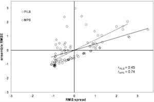
Analysis of ensemble forecasting strategies, which can provide a tangible backing for flood early warning procedures and mitigation measures over the Mediterranean region, is one of the fundamental motivations of the international HyMeX programme. Here, we examine two severe hydrometeorological episodes that affected the Milano urban area and for which the complex flood protection system of the city did not completely succeed. Indeed, flood damage have exponentially increased during the last 60 years, due to industrial and urban developments. Thus, the improvement of the Milano flood control system needs a synergism between structural and non-structural approaches. First, we examine how land-use changes due to urban development have altered the hydrological response to intense rainfalls. Second, we test a flood forecasting system which comprises the Flash-flood Event-based Spatially distributed rainfall–runoff Transformation, including Water Balance (FEST-WB) and the Weather Research and Forecasting (WRF) models. Accurate forecasts of deep moist convection and extreme precipitation are difficult to be predicted due to uncertainties arising from the numeric weather prediction (NWP) physical parameterizations and high sensitivity to misrepresentation of the atmospheric state; however, two hydrological ensemble prediction systems (HEPS) have been designed to explicitly cope with uncertainties in the initial and lateral boundary conditions (IC/LBCs) and physical parameterizations of the NWP model. No substantial differences in skill have been found between both ensemble strategies when considering an enhanced diversity of IC/LBCs for the perturbed initial conditions ensemble. Furthermore, no additional benefits have been found by considering more frequent LBCs in a mixed physics ensemble, as ensemble spread seems to be reduced. These findings could help to design the most appropriate ensemble strategies before these hydrometeorological extremes, given the computational cost of running such advanced HEPSs for operational purposes.
Citation:
2016. Potential of sequential EnKF for the short-range prediction of a maritime severe weather event
Carrió, D.S, and Homar, V.
DOI: 10.1016/j.atmosres.2016.04.011
IF: 3.778 - Q1
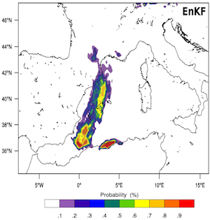
The Western Mediterranean coastlands are persistently affected by severe phenomena related to maritime con- vective systems. Areas with low density of observations around highly populated regions pose serious forecasting challenges due to the risk of misrepresenting crucial structures. This forecast problem is exemplified by the squall line that affected Mallorca (Spain) on 4th October 2007. Ensemble Kalman Filter (EnKF) assimilation algorithms exploit the statistical information conveyed by ensembles and are specially suited for regions with poor knowl- edge about climatological error statistics and covariances. We investigate the potential for predictability im- provement from the assimilation of standard observations in the squall line event. Ensemble forecasts are assessed in terms of probabilistic products which clearly bring out the differences between assimilation and con- trol experiments. Results show the large improvements rendered by the EnKF system in terms of severe weather threat. The attribution of these improvements is discussed in terms of the environmental ingredients linked to squall line formation. Experiments reveal that forecast improvements are fully attributable to the ability of EnKF to accurately represent the convergent flow over the Alboran Sea responsible for the thunderstorm initia- tion. Additional sensitivity experiments are performed to confirm the hypothesised primary role of the terrestrial observations in the accurate representation of the low-level convergent flow. These experiments confirm the ability of the sequential assimilation system in conveying crucial observational information from terrestrial to marine areas, and thus bestowing the EnKF a central role in future upgrades of high impact weather prediction systems in the Western Mediterranean region.
Citation:
2015. Potential of a probabilistic hydrometeorological forecasting approach for the 28 September 2012 extreme flash flood in Murcia, Spain
Amengual, A., Homar, V., and Jaume, O.
DOI: 10.1016/j.atmosres.2015.06.012
IF: 3.377 - Q1

An improved understanding, modeling and forecasting of hydrometeorological extremes over the flood-prone Western Mediterranean region is one of the milestones of the international HyMeX program. A set of severe hydrometeorological episodes affected various basins across south and eastern Mediterranean Spain from 27 to 29 September 2012. Flooding was particularly catastrophic in Andalusia and Murcia, where 10 fatalities occurred and material losses were estimated at 120 M€. The predictability bounds set by the type and scales of the processes involved in such high-impact episodes require the explicit representation of uncertainty in the hydrometeorological forecasting chain. A short-range ensemble prediction system (EPS) provides the optimal framework to generate risk-based forecasts supporting valuable early warning procedures and mitigation measures. We explore the potential of this probabilistic forecasting approach on the 28 September 2012 flash flood in the Guadalentín river basin, a medium-sized catchment located in Murcia, southeastern Spain. After a rigorous calibration with rain-gauge data, the hydrological response of the basin to this flooding is accurately simulated by the Hydrologic Engineering Center's Hydrological Modeling System runoff model. Then, we explore the uncertainty transference from a collection of mesoscale meteorological deterministic and probabilistic 48 h predictions provided by the Weather Research and Forecasting (WRF) model. The meteorological simulations are nested within the global EPS of the European Centre for Medium-Range Weather Forecasts, therefore inheriting the spread of the global system and providing probabilistic high-resolution precipitation structures to the hydrological model. By assuming the calibrated model as a good representation of a perfect hydrological model for this event, it becomes an advanced and user-oriented verification tool for quantitative precipitation forecasts. Results highlight the benefits of accounting for uncertainties in the precipitation forecasts and the value of the proposed set-up for the short-range prediction of quantitative discharge forecasts. The warn-on-forecast approach is shown to be possible within a probabilistic hydrometeorological forecasting chain for basins as small and fast-responsive as the Guadalentín basin, proving to be suitable for civil protection warning procedures.
Citation:
2014. Projections for the 21st century of the climate potential for beach-based tourism in the Mediterranean
Amengual, A., Homar, V., Romero, R., Ramis, C., and Alonso, S.
DOI: Int. J. Climatol. 34: 3481–3498 (2014), 10.1002/joc.3922
IF: 3.157 - Q1

Climate is a primary resource for beach-based tourism. It defines the length and quality of the tourist season and plays a major role in destination choices and revenues. The Mediterranean is coincidentally one of the most visited tourist destinations and sensitive areas to climate change worldwide. Social, economic and environmental adaptation to climate change in this region should necessarily evaluate the Mediterranean and European climate resource for beach-based tourism as well as its projected changes. To this end, the second-generation climate index for tourism (CIT) has been adopted. ERA-Interim reanalysis have been used as the regional observed baseline, thus providing daily atmospheric data to derive CIT. For projections, meteorological variables have been obtained from a set of regional climate models (RCMs) within the ENSEMBLES European project. A quantile–quantile adjustment has been applied to the CIT cumulative distribution functions based on each individual RCM output to properly correct biases at regional and local scales. Furthermore, an ensemble strategy is adopted to further cope with uncertainties arising from RCM errors and boundary conditions. The spatial distribution of present climate potential confirms the Mediterranean coast as the most suitable region in Europe for carrying out beach leisure activities. Excellent climatic conditions prevail in most of this coastal region during summer. However, the optimal climate asset is projected to noticeably deteriorate in summer across the Mediterranean, whereas only slightly improving in northwestern Europe by 2075–2094. On the other hand, a general enhancement of ideal climate potential is expected for the shoulder seasons in the former region. That is, optimal climatic conditions may shift from the present peak demand season to spring and autumn. These potential impacts might lead to important drawbacks for the current strongly seasonal-adjusted beach-based tourism industry in the Mediterranean. Therefore, main tourism stakeholders will likely need to face these challenges through adaptation and mitigation strategies.
Citation:
2014. Projections of heat waves with high impact on human health in Europe
Amengual, A., Homar, V., Romero, R., Brooks, H.E., Ramis, C., Gordaliza, M., and Alonso, S.
Global and Planetary Change 119 (2014) 71–84
IF: 2.766 - Q1
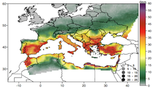
Climate change will result in more intense, more frequent and longer lasting heat waves. The most hazardous conditions emerge when extreme daytime temperatures combine with warm night-time temperatures, high humidities and light winds for several consecutive days. Here, we assess present and future heat wave impacts on human health in Europe. Present daily physiologically equivalent temperatures (PET) are derived from the ERA-Interim reanalysis. PET allows to specifically focus on heat-related risks on humans. Regarding projections, a suite of high-resolution regional climate models – run under SRES A1B scenario – has been used. A quantile– quantile adjustment is applied to the daily simulated PET to correct biases in individual model climatologies and a multimodel ensemble strategy is adopted to encompass model errors. Two types of heat waves differently impacting human health – strong and extreme stress – are defined according to specified thresholds of thermal stress and duration. Heat wave number, frequency, duration and amplitude are derived for each type. Results re- veal relatively strong correlations between the spatial distribution of strong and extreme heat wave amplitudes and mortality excess for the 2003 European summer. Projections suggest a steady increase and a northward extent of heat wave attributes in Europe. Strong stress heat wave frequencies could increase more than 40 days, lasting over 20 days more by 2075–2094. Amplitudes might augment up to 7 °C per heat wave day. Important increases in extreme stress heat wave attributes are also expected: up to 40 days in frequency, 30 days in duration and 4 °C in amplitude. We believe that with this information at hand policy makers and stake- holders on vulnerable populations to heat stress can respond more effectively to the future challenges imposed by climate warming.
Citation:
2014. On the severe convective storm of 29 October 2013 in the Balearic Islands: observational and numerical study
Romero, R., Ramis, C., and Homar, V.
Q. J. R. Meteorol. Soc. (2014) DOI:10.1002/qj.2429
IF: 3.252 - Q1
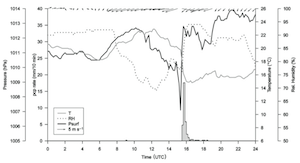
On 29 October 2013, a severe squall line developed to the west of the Balearic Islands (Spain) ahead of an advancing cold front and then crossed the archipelago. We first provide an observational characterization of the event based on surface reports, remote sensing products, radiosoundings and synoptic information. We also achieve, by means of numerical experiments, new insights into the kinematic and thermodynamic factors that governed the genesis and evolution of the linear convective system. Radar and satellite images confirm the fast movement and linear shape of the system, with an indication of a possible transition into a bow-echo structure during its later stages. The synoptic setting at mid-upper tropospheric levels was dominated by a cold trough extended over western Europe, associated with a jet stream located downstream. Convection evolved under the right entrance region of the jet and initiated under the crucial influence of a surface low that developed over the Mediterranean Sea ahead of the cold front. The low not only cooperated with the upper-level dynamical forcing to erode a capping inversion initially present over the Balearics and moisten the atmospheric column above, but also shaped and enhanced a convergence line along which the first convective cells grew and self-aggregated. This scenario is confirmed by numerical simulations of the case, which also emphasize the important role of regional topography in the production of the aforementioned maritime convergence through the mesoscale modulation of the low-level flow. Additional simulations show that (i) the destabilization of the low-level air mass necessary for triggering and feeding an organized convective system on 29 October 2013 was attributable to prior evaporation from the Mediterranean and (ii) sea-surface temperatures appear to be critical for a successful fine-grid numerical forecast of the mode, degree of severity, timing and track of the convective precipitation system.
Citation:
2014. HyMeX, a 10-year multidisciplinary program on the Mediterranean water cycle
Drobinski, P., Ducrocq, V., Alpert, P., Anagnostou, E., Béranger, K., Borga, M., Braud, I., Chanzy, A., Davolio, S., Delrieu, G., Estournel, C., Filali Boubrahmi, N., Font, J., Grubisic, V., Gualdi, S., Homar, V., Ivancan-Picek, B., Kottmeier, C., Kotroni, V., Lagouvardos, K., Lionello, P., Llasat, M.C., Ludwig, W., Lutoff, C., Mariotti, A., Richard, E., Romero, R., Rotunno, R., Roussot, O., Ruin, I., Somot, S., Taupier-Letage, I., Tintore, J., Uijlenhoet, R., and Wernli, H.
Bull. Amer. Meteorol. Soc. DOI 10.1175/BAMS-D-12-00242.1
IF: 11.808 - Q1
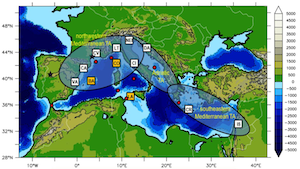
The Mediterranean countries are experiencing important challenges related to the water cycle including water shortages and floods, extreme winds and ice/snow storms that impact critically the socioeconomic vitality in the area (causing damage to property; threatening lives; affecting the energy and transportation sectors, etc.). There are gaps in our understanding of the Mediterranean water cycle and its dynamics, which include the variability of the Mediterranean Sea water budget and its feedback on the variability of the continental precipitation through air/sea interactions, the impact of precipitation variability on aquifer recharge, river discharge, soil water content and vegetation characteristics specific of the Mediterranean basin and the mechanisms that control the location and intensity of heavy precipitating systems which often produce floods. The HyMeX (Hydrological cycle in the Mediterranean Experiment) programme is a 10-year concerted experimental effort at the international level aiming at advancing the scientific knowledge of the water cycle variability in all compartments (land, sea and atmosphere) and at various time and spatial scales. It also aims at improving the processes-based models needed for forecasting hydro-meteorological extremes and the models of the regional climate system for predicting regional climate variability and evolution. It finally aims at assessing the social and economic vulnerability to hydrometeorological natural hazards in the Mediterranean and the adaptation capacity of the territories and populations therein to provide support to policy makers to cope with water related problems under the influence of climate change, by linking scientific outcomes with related policy requirements.
Citation:
2014. Present and future climate resources for various types of tourism in the Bay of Palma, Spain
Bafaluy, D., Amengual, A., Romero, R., and Homar, V.
Reg. Environ. Change. DOI 10.1007/s10113-013-0450-6
IF: 2.628 - Q2
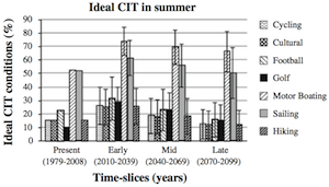
The Bay of Palma, in Mallorca, is a leading region for beach holidays in Europe. It is based on a mass tourism model strongly modulated by seasonality and with high environmental costs. Main tourism stakeholders are currently implementing complementary activities to mitigate seasonality, regardless of climate change. But climate is —and will remain— a key resource or even a limitation for many types of tourism. Assessing the present conditions and exploring the future evolution of climate potential for these activities have become a priority in this area. To this end, the climate index for tourism (CIT) —originally designed to rate the climate resource of beach tourism— is adapted to specifically appraise cycling, cultural tourism, football, golf, motor boating, sailing and hiking. Climate resources are derived by using observed and projected daily meteorological data. Projections have been obtained from a suite of Regional Climate Models run under the A1B emissions scenario. To properly derive CITs at such local scale, we apply a statistical adjustment. Present climate potentials ratify the appropriateness of the Bay of Palma for satisfactorily practicing all the examined activities. However, optimal conditions are projected to degrade during the peak visitation period while improving in spring and autumn. That is, climate change could further exacerbate the present imbalance between the seasonal distributions of ideal climate potentials and high attendance levels. With this information at hand, policy makers and regional tourism stakeholders can respond more effectively to the great challenge of local adaptation to climate change.
Citation:
2014. Are current sensitivity products sufficiently informative in targeting campaigns? A DTS-MEDEX-2009 case study
Garcies, L., and Homar, V.
Q. J. R. Meteorol. Soc., 140: 525–538. doi: 10.1002/qj.2148
IF: 3.252 - Q1
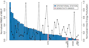
The DTS-MEDEX-2009 campaign was a field experiment in which extra observations were adaptively deployed to improve the short-range forecast of Mediterranean high-impact weather (HIW) during autumn 2009. For the DTS-MEDEX-2009 cases, five different sensitivity analysis techniques were carried out to provide targeting guidance: singular vectors (SV) from the ECMWF; ensemble transform Kalman filter (ETKF) and Kalman filter sensitivity (KFS) from Météo France; and ensemble and adjoint sensitivities from the University of the Balearic Islands. However, the value of the targeting guidance provided by such a variety of sensitivity products has never been assessed for a Mediterranean HIW event. Since radiosonde and AMDAR profiles were the only observational means available during the DTS- MEDEX targeting campaign, this study tests the ability of each sensitivity product in identifying the region where a plausible sounding leads to a greater impact on the forecast of a potential high-impact cyclone over southern Italy on 5 December 2009. All targetable radio-sounding sites are also tested and a severe-weather meteorologist is used as a confronting reference. The verification testbed comprehends single sounding experiments and multiple sounding strategies by using the WRF Data Assimilation system. Single sounding tests reveal that sensitivity products fail to recognize the best location for a single observation since most of the soundings added over operational radio-sounding stations have a larger influence on intense cyclone forecast than the points highlighted by the objective sensitivity calculation methods. Additionally, it is shown that human-based decisions, after evaluating available sensitivity information, are not optimal, either in single or in multiple sounding strategies.
Citation:
2013. A non-hydrostatic global spectral dynamical core using a height-based vertical coordinate
Simarro, J., Homar, V., and Simarro, G.
Tellus A, 65, 20270
IF: 2.518 - Q2
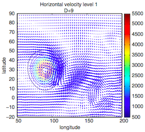
Most of the dynamical cores of operational global models can be broadly classified according to the spatial discretisation into two categories: spectral models with mass-based vertical coordinate and grid point models with height-based vertical coordinate. This article describes a new non-hydrostatic dynamical core for a global model that uses the spectral transform method for the horizontal directions and a height-based vertical coordinate. Velocity is expressed in the contravariant basis (instead of the geographical orthonormal basis pointing to the East, North and Zenith directions) so that the expressions of the boundary conditions and the divergence of the velocity are simpler. Prognostic variables in our model are the contravariant components of the velocity, the logarithm of pressure and the logarithm of temperature. Covariant tensor analysis is used to derive the differential operators of the prognostic equations, such as the curl, gradient, divergence and covariant derivative of the contravariant velocity. A Lorenz type grid is used in the vertical direction, with the vertical contravariant velocity staggered with respect to the other prognostic variables. High-order vertical operators are constructed following the finite difference technique. Time stepping is semi-implicit because it allows for long time steps that compensates the cost of the spectral transformations. A set of experiments reported in the literature is implemented so as to confirm the accuracy and efficiency of the new dynamical core.
Citation:
2013. Daily precipitation records over mainland Spain and the Balearic Islands
Ramis, C., Homar, V., Amengual, A., Romero, R., and Alonso, S.
Nat. Hazards Earth Syst. Sci., 13, 2483–2491
IF: 1.826 - Q2
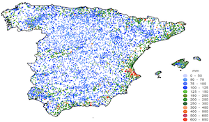
Understanding the spatial distribution of extreme precipitations is of major interest in order to improve our knowledge of the climate of a region and its relationship with society. These analyses inevitably require the use of directly observed values to account for the actual extreme amounts rather than analyzed gridded values. A study of daily rainfall extremes observed over mainland Spain and the Balearic Islands is performed by using records from 8135 rain gauge stations from the Spanish Weather Agency (AEMET). Results show that the heaviest daily precipitations have been observed mainly on the coastal Mediterranean zone from Gibraltar to the Pyrenees. In particular, a record value of 817 mm was recorded in the Valencia region in 1987. The current map of daily records in Spain, which updates the pioneering work of the Spanish meteorologist Font, shows similar distribution of extreme events but with notably higher amounts. Generalized extreme values distributions fit the Mediterranean and Atlantic rain gauge measurements and shows the different characteristics of the extreme daily precipitations in both regions. We identify the most extreme events (above 500 mm per day) and provide a brief description of a typical meteorological situation in which these damaging events occur. An analysis of the low-level circulation patterns producing such extremes – by means of simple indices such as NAO, WeMOi and IBEI – confirms the relevance of local flows in the generation of either Mediterranean or Atlantic episodes. WeMOi, and even more IBEI, are good discriminants of the region affected by the record precipitation event.
Citation:
2012. A look to the HyMeX program
Quintana, P., Homar, V., Llasat, M.C., Jansà, A., Font, J., and Aran, M.
Tethys, 9, 53-63
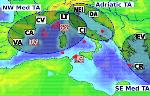
The international HyMeX (Hydrological Mediterranean Experiment) program aims to improve our understanding of the water cycle in the Mediterranean, using a multidisciplinary and multiscale approach and with emphasis on extreme events. This program will improve our understanding and our predictive ability of hydrometeorological hazards including their evolution within the next century. One of the most important results of the program will be its observational campaigns, which will greatly improve the data available, leading to significant scientific results. The interest of the program for the Spanish research groups is described, as the active participation of some of them in the design and execution of the observational activities. At the same time, due to its location, Spain is key to the program, being a good observation platform. HyMeX will enrich the work of the Spanish research groups, it will improve the predictive ability of the weather services, will help us to have a better understanding of the impacts of hydrometeorological extremes on our society and will lead to better strategies for adapting to climate change.
Citation:
2012. A Statistical Adjustment of Regional Climate Model Outputs to Local Scales: Application to Platja de Palma, Spain
Amengual, A., Homar, V., Romero, R., Alonso, S., and Ramis, C.
J. Clim., 25, 939-957
IF: 4.362 - Q1
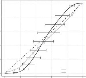
Projections of climate change effects for the System of Platja de Palma (SPdP) are derived using a novel statistical technique. Socioeconomic activities developed in this settlement are very closely linked to its climate. Any planning for socioeconomic opportunities in the mid- and long term must take into account the possible effects of climate change. To this aim, daily observed series of minimum and maximum temperatures, precipitation, relative humidity, cloud cover, and wind speed have been analyzed. For the climate projections, daily data generated by an ensemble of regional climate models (RCMs) have been used. To properly use RCM data at local scale, a quantile–quantile adjustment has been applied to the simulated regional projections. The method is based on detecting changes in the cumulative distribution functions between the recent past and successive time slices of the simulated climate and applying these, after calibration, to the recent past (observed) series. Results show an overall improvement in reproducing the present climate baseline when using calibrated series instead of raw RCM outputs, although the correction does not result in such clear improvement when dealing with very extreme rainfalls. Next, the corrected series are analyzed to quantify the climate change signal. An increase of the annual means for temperatures together with a decrease for the remaining variables is projected throughout the twenty-first century. Increases in weak and intense daily rainfalls and in high extremes for daily maximum temperature can also be expected. With this information at hand, the experts planning the future of SPdP can respond more effectively to the problem of local adaptation to climate change.
Citation:
2011. Ensemble prediction of Mediterranean high-impact events using potential vorticity perturbations. Part II: Adjoint-derived sensitivity zones
Vich, M., Romero, R., and Homar, V.
Atmos. Res., 102, 311-319
IF: 1.911 - Q2
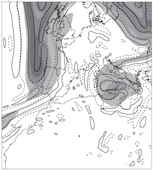
In Part I of this work, an ensemble prediction system (EPS) based on different combinations of model physical parameterizations was compared against another ensemble based on perturbing initial and boundary conditions through the Potential Vorticity (PV) field. This comparison was done for western Mediterranean cyclonic situations associated with high-impact weather phenomena such as heavy rain and showed a better performance of the PV-perturbed ensemble over the more traditional multiphysics approach. The current study extends the comparison to another ensemble based on perturbing initial and boundary conditions through the PV field but guided by the MM5 adjoint derived sensitivity zones (PV-adjoint) instead of by the three-dimensional PV features showing intense values and gradients as was done in Part I (PV-gradient).
The PV-adjoint and PV-gradient EPSs perturb specific areas of the cyclonic development using a PV error climatology that typifies PV errors in the initial and boundary conditions to provide the appropriate error range. The non-hydrostatic MM5 mesoscale model nested in the ECMWF forecast fields is used to provide all predictions.
For the studied cases, 19 cyclonic events associated with heavy rain, the verification results show that both PV-perturbed are skillful, the PV-gradient being the best. Therefore, for our testbed, the extra computational cost of running the MM5 adjoint model does not provide a significant ensemble skill improvement.
Citation:
2011. Projections of the climate potential for tourism at local scales: Application to Platja de Palma, Spain
Amengual, A., Homar, V., Romero, R., Alonso, S., and Ramis, C.
Int. J. Climatol., 31
IF: 2.906 - Q1
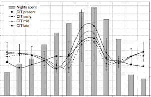
Primary socioeconomic activities in the System of Platja de Palma (SPdP), located in the southwestern coast of Mallorca, Spain, are beach-based holidays and, therefore, are very closely linked to climate. The social, economic and environmental adaptation that this region must make in the mid- and long-term period has to take into account the changes in the tourist potential when the climate changes. A second-generation climate index for tourism (CIT) has been adopted to measure tourism potential under the present and possible future climatic conditions. CIT is a theoretically based and empirica lly derived index that allows assessing the sun, sea and sand (3S) weather resource. Daily observed series of 2 m maximum temperature, precipitation, 2 m relative humidity, cloud cover and 10 m wind speed have been used to derive the present climate potential for tourism. For future projections, daily averaged meteorological variables have been obtained from a set of regional climate models (RCMs) within the European ENSEMBLES project. The adoption of a multimodel ensemble strategy allows quantifying the uncertainties arising from model errors and boundary conditions. To use CIT values based on RCM data properly at local scales, a quantile–quantile adjustment has been applied. Results show a significant increase in the annual frequency of days with acceptable conditions together with a slightly increment for the ideal climate perceptions at the expense of decreasing unacceptable categories. For the summery peak season, ideal conditions are projected to decrease from mid-century favouring acceptable categories. However, an almost general increase for both classes is anticipated in spring and autumn throughout the century. That is, higher frequencies of optimal climate perceptions for carrying out 3S outdoors activities are expected to shift from the peak to shoulder seasons. Therefore, climate change would result in a major impact for the current seasonally adjusted service sector in SPdP. With this information, policy makers and the team of experts planning its socioeconomic future can respond more effectively to the demanding challenge of local adaptation to climate change by implementing adaptation and mitigation strategies to the tourist sector.
Citation:
2011. Verification of objective sensitivity climatologies of Mediterranean intense cyclones: test against human judgement
Garcies, L., and Homar, V.
Q. J. R. Meteorol. Soc., 137, 1467-1481
IF: 2.907 - Q1
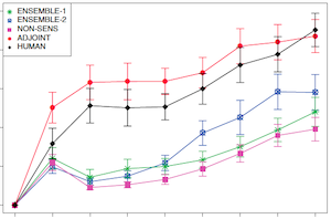
A variety of sensitivity climatologies of Mediterranean intense cyclones have been recently built owing to the growing international interest in contributing to the basic understanding and the short-range forecasting of high-impact weather events. The verification of these climatologies is essential to ensure the reliability of the sensitivity products and ultimately provide robust guidance to policy-makers on plans to redefine routine observational strategies. This work tackles the arduous task of verifying the available (an adjoint-based and two different ensemble-based) sensitivity climatologies of Mediterranean intense cyclones. We perform Observing System Simulation Experiments (OSSE) with the WRF ARW model for 25 of the most intense Mediterranean cyclones detected in the ERA-40 database to test the ability of each method in identifying areas where perturbations in the initial conditions derived from the sensitivity fields lead to a greater impact on the forecast of intense cyclones. For the sake of a sensible reference, the performance of the available sensitivity climatologies is tested against the judgement of an experienced severe weather meteorologist. In addition, a control measure of the background random response is also carried out. The impact on the prediction of intense Mediterranean cyclones of prescribed perturbations to the initial conditions is evaluated comparing each perturbed experiment with a control simulation. Furthermore, a quantitative study of the linearity of the evolution of the perturbations is performed using twin perturbations. Results confirm a statistically significant superior skill of the human and adjoint sensitivity fields against both ensemble sensitivity climatologies. Climatological ensemble sensitivities only show a noticeable improvement upon non-sensitivity experiments when an ad hoc classification of cyclones is used. This reveals one fundamental limitation of the ensemble sensitivity technique in climatological mode when it is applied to rare events insufficiently sampled in the availabledatasets.
Citation:
2011. A new approach to sensitivity climatologies: the DTS-MEDEX-2009 campaign
Jansà, A., Arbogast, P., Doerenbecher, A., Garcies, L., Genovés, A., Homar, V., Klink, S., Richardson, D., and Sahin, C.
Nat. Hazards Earth Syst. Sci., 11, 2381-2390
IF: 1.983 - Q1
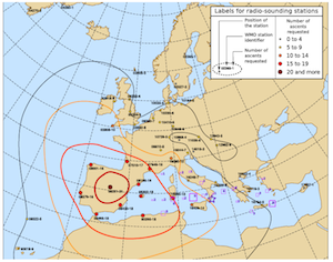
Adaptive observation is an approach to improving the quality of numerical weather forecasts through the optimization of observing networks. It is sometimes referred to as Data Targeting (DT). This approach has been applied to high impact weather during specific field campaigns in the past decade. Adaptive observations may involve various types of observations, including either specific research observing platforms or routine observing platforms employed in an adaptive way. The North-Atlantic TReC 2003 and the EURORISK-PREVIEW 2008 exercises focused on the North-Atlantic and Western Europe areas using mainly routine observing systems. These campaigns also included Mediterranean cases.
The most recent campaign, DTS-MEDEX-2009, is the first campaign in which the DT method has been used to address exclusively Mediterranean high impact weather events. In this campaign, which is an important stage in the MEDEX development, only operational radiosonde stations and commercial aircraft data (AMDAR) have provided additional observations. Although specific diagnostic studies are needed to assess the impact of the extra-observations on forecast skill and demonstrate the effectiveness of DTS-MEDEX-2009, some preliminary findings can be deduced from a survey of this targeting exercise.
After a description of the data targeting system and some illustrations of particular cases, this paper attempts some comparisons of additional observation needs (through effectively deployed radio-soundings) with sensitivity climatologies in the Mediterranean. The first step towards a sensitivity climatology for Mediterranean cases of high impact weather is indirectly given by the frequency of extrasoundings launched from the network of radiosonde stations involved in the DTS-MEDEX-2009 campaign.
Citation:
2011. Spatial heterogeneity in the effects of climate change on the population dynamics of a Mediterranean tortoise
Fernández-Chacón, A., Bertolero, A., Amengual, A., Tavecchia, G., Homar, V., and Oro, D.
Glob. Change Biol., 17, 3075-3088
IF: 6.862 - Q1
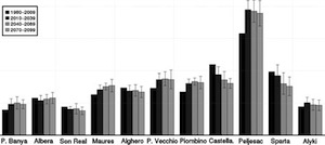
Climatic shifts may increase the extinction risk of populations, especially when they are already suffering from other anthropogenic impacts. Our ability to predict the consequences of climate change on endangered species is limited by our scarce knowledge of the effects of climate variability on the population dynamics of most organisms and by the uncertainty of climate projections, which depend strongly on the region of the earth being considered. In this study, we analysed a long-term monitoring programme (1988–2009) of Hermann's tortoise (Testudo hermanni) aimed at evaluating the consequences of the drastic changes in temperature and precipitation patterns predicted for the Mediterranean region on the demography of a long-lived species with low dispersal capability and already suffering a large number of threats. Capture–recapture modelling of a population in the Ebro Delta (NE Spain) allowed us to assess the effect of climate variability on the survival of tortoises. Winter rainfall was found to be the major driver of juvenile and immature survival, whereas that of adults remained high and constant across the study. Furthermore, local climate series obtained ad hoc from regional climate simulations, for this and 10 additional Mediterranean locations where tortoises occurred, provided us with reliable future climate forecasts, which were used to simulate the fate of these populations under three precipitation scenarios (mean, wet and dry) using stochastic population modelling. We show that a shift to a more arid climate would have negative consequences for population persistence, enhancing juvenile mortality and increasing quasiextinction risk because of a decrease in recruitment. These processes varied depending on the population and the climate scenario we considered, but our results suggest that unless other human-induced causes of mortality are suppressed (e.g. poaching, fire, habitat fragmentation), climate variability will increase extinction risk within most of the species' current range.
Citation:
2011. Initiation of a severe thunderstorm over the Mediterranean Sea
Cohuet, J.B., Romero, R., Homar, V., Ducrocq, V., and Ramis, C.
Atmos. Res., 100, 603-620
IF: 1.911 - Q2
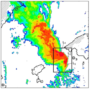
The Mediterranean basin is regularly affected by severe weather associated with deep convection. Although convective systems are usually linked to coastal orography, some severe thunderstorms develop and mature over the sea. A recent example is the severe thunderstorm that affected the island of Mallorca in the afternoon of 4 October 2007. The storm formed early in the morning offshore of Murcia, and steadily became organized into a squall line. Arriving in Palma city, this squall line produced severe gusts, heavy rain and several tornadoes. The initiation and evolution of convection in these kinds of maritime events depend on both synoptic and mesoscale features. Representing such interactions is a challenge for numerical weather prediction. The aim of this study is to determine the prominent factors involved in the initiation and evolution of the damaging squall line, by means of high resolution numerical experiments. We also focus on squall line mesovortices to explain the potential for tornado development and the role of Mallorcan orography on their evolution.
Simulations performed with the mesoscale model Méso-NH allowed relevant mechanisms for initiation and development of the strong squall line to be identified. The squall line initiates in an area with conditional instability, characterized by a cut-off and a southerly jet aloft and by moist, warm air at low-levels along a front. In addition, the area of low-level convergence offshore of Murcia, associated with the front and enhanced by a low downstream of the Atlas range, was shown to be crucial during the early stage of the convective system. The dry layer in the mid-troposphere and the strong sheared environment provide elements for understanding the development of such a damaging squall line. Moreover, a very high resolution experiment (600 m mesh) gave a very realistic representation of the squall line, including mesovortices ahead of the gust front, which confirmed the potential of this strong convective system for the genesis of small-scale vortices that may precede tornado development. A sensitivity experiment pointed out the prominent role of Mallorcan orography in straightening mesovortices approaching Palma city, and provided interesting elements for the understanding of the localization of tornadoes that occurred on 4 October 2007.
Citation:
2010. An optimized ensemble sensitivity climatology of Mediterranean intense cyclones
Garcies, L., and Homar, V.
Nat. Hazards Earth Syst. Sci., 10, 2441-2450
IF: 1.792 - Q1
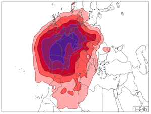
A new approach was recently proposed to compute climatological statistical sensitivities. It was applied on an already available classification of Mediterranean intense cyclones. However, those sensitivity results are questionable due to the limited homogeneity of some cyclone classes, which severely hampers the application of the statistical sensitivity analysis technique. In this study, a new classification of Mediterranean intense cyclones is built with the aim of improving the reliability of the final climatological sensitivity results. In addition to implementing a regional classification and a subsequent division according to the preceding conditions that lead to cyclone formation, a cluster pruning is applied to maximize the homogeneity of the classes. The increased cluster homogeneity and the higher significance of the obtained sensitivity estimates are quantified. Furthermore, the improved representativeness of the sensitivity fields derived after cluster pruning is tested and compared to previous results by means of numerical experiments. Eventually, summary sensitivity fields highlight the European Atlantic coasts, central and western Europe, the central and western Mediterranean basin and north african lands as sensitive regions for the evolution of these Mediterranean high-impact systems. Although some outstanding improvements are confirmed in this study, a further verification experiments are needed to objectively verify the sensitivity results and build solid confidence on the method.
Citation:
2010. Recent trends in temperature and precipitation over the Balearic Islands (Spain)
Homar, V., Ramis, C., Romero, R., and Alonso, S.
Clim. Change, 98, 199-211?
IF: 3.016 - Q1
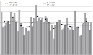
Changes in climatic parameters are often given in terms of global averages even though large regional variability is generally observed. The study of regional tendencies provides not only supplementary conclusions to more large-scale oriented results but is also of particular interest to local policy-makers and resource managers to have detailed information regarding sensible and influential climatic parameters. In this study, changes in precipitation for the Balearic Islands (Spain) have been analyzed using data from 18 rain gauges with complete daily time series during the period 1951–2006 and two additional sites where only monthly totals were available. Tendencies for maximum and minimum 2-m temperatures have also been derived using data from three thermometric stations with daily time series for the period 1976–2006. The thermometric stations are located at the head of the runways in the airports of the three major islands of the archipelago, where urbanization has arguably not had a relevant impact on the registered values. The annual mean temperature in the mid-troposphere and lower stratosphere has also been analyzed using the Balearics radiosonde data for the period 1981–2006. Results show there is a negative tendency for annual precipitation (163 mm per century) with 85% significance on the sign of the trend. An abrupt decrease in mean yearly precipitation of 65 mm is objectively detected in the time series around 1980. Additionally, the analysis shows that light and heavy daily precipitation (up to 4 mm and above 64 mm, respectively) increase their contribution to the total annual, while the share from moderate-heavy precipitations (16–32 mm) is decreasing. Regarding the thermometric records, minimum temperatures increased at a rate of 5.8◦C per century during the 31 years and maximum temperatures also increased at a rate of 5.0◦C per century, both having a level of statistical significance for the sign of the linear trend above 99%. Temperatures in the mid-troposphere decreased at a rate of −5.4◦C per century while a tendency of −7.8◦C per century is found in the lower stratosphere. The level of statistical significance for the sign of both the tropospheric and stratospheric linear trends is above 98% despite the great inter-annual variability of both series.
Citation:
2009. The severe thunderstorm of 4 October 2007 in Mallorca: an observational study
Ramis, C., Romero, R., and Homar, V.
Nat. Hazards Earth Syst. Sci., 9, 1237-1245
IF: 1.357 - Q2
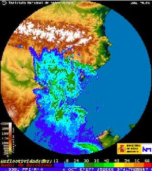
During the afternoon of 4 October 2007, a thunderstorm swept across the Island of Mallorca from south-west to northeast. Strong straight-line winds (up to 30 m/s) and heavy rain (rates up to 100 mm/h) were registered accompanying the storm. Tornadoes with an estimated intensity of F2–F3 developed nearby the city of Palma, severely affecting industrial installations. One person was killed by the impact of heavy debris while more than 10 million C in damages were attributed to the event in the industrial area only. The observed evolution of temperature, humidity, wind and pressure, as well as the sequence of radar images, reveal that a squall line was initially organized over the sea and then moved north-eastwards at an estimated speed of around 80 km/h. This paper presents an analysis of the event from an observational point of view. The aim of the study is to contribute to the characterization of these rare events in the Western Mediterranean by analyzing the observational information available for this particular extreme event. The diagnosis is aimed at helping forecasters to identify this kind of organized deep convective events and being able to issue timely warnings. The synoptic scenario shows warm and moist advection at low levels over Balearics and an upper-level trough over mainland Spain. This situation is known to be prone to deep convection in Mediterranean Spain in autumn. Radiosonde ascents from Murcia and Palma show convective instability at mid levels that can conduce to develop convection if appropriate ascents occur. A plausible lifting mechanism to trigger convection is attributed to large amplitude gravity waves, registered as short-period pressure oscillations by surface barographs.
Citation:
2009. Ensemble sensitivities of the real atmosphere: application to Mediterranean intense cyclones
Garcies, L., and Homar, V.
Tellus Ser. A-Dyn. Meteorol. Oceanol., 61A, 394-406
IF: 2.214 - Q1
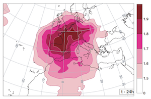
Ensemble sensitivity has been recently proposed as an alternative cheap approach to sensitivity analysis. We adapt it to compute climatological sensitivity estimates of intense Mediterranean cyclones using a climatology based of the ECMWF ERA-40 fields. A catalogue of 1202 events, objectively detected and classified in 25 clusters, is used in this study. Sensitivity fields are derived for each intense Mediterranean cyclone type by correlating the precursor conditions with the mature cyclones depths. Corrections to the raw sensitivity estimates are applied by means of the correlation coefficient. Further, a normalization based on the climatological spatial variability of the variance of the precursor conditions is used to derive the final sensitivity fields. The 24 h sensitivity information derived for each intense Mediterranean cyclone type is easily interpretable both in amplitude and distribution. A synthetic result combining the sensitivity fields for all 25 intense Mediterranean cyclone classes shows that the evolution of these high-impact systems 24 h prior to its maturity stage depends largely on structures located over Western Europe, the Northern African lands and parts of east North Atlantic. These results are in agreement and complement with previous results obtained with the expensive adjoint model, although further work is needed to objectively verify the results.
Citation:
2008. Subjective versus objective sensitivity estimates: application to a North African cyclogenesis
Homar, V., and Stensrud, D.J.
Tellus Ser. A-Dyn. Meteorol. Oceanol., 60A, 1064-1078
IF: 1.965 - Q2
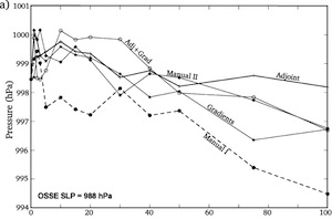
An observing system simulation experiment is used to test and compare objective and subjective estimates of sensitivity of a forecast aspect to the initial condition (IC) fields for a case of rapidly developing cyclogenesis over the Western Mediterranean during 19–22 December 1979. The ability of sensitivity estimation methods to provide helpful guidance about where an improvement in the IC can lead to the largest forecast error reduction is particularly important to ascertain in order to guide adaptive observation campaigns. Synthetic soundings from a 15-km reference simulation are added to an initially poor 60-km control simulation over the sensitive areas as determined by the combination of the given sensitivity estimate and a simple analysis error estimate. The ability of each sensitivity estimation method to produce an improved simulation of the cyclone is assessed. Results show that while the sensitivity estimates perform similarly, with no significant differences among them, the subjective method yields the best overall targeting guidance. In contrast, the adjoint estimate provides the least accurate targeting guidance for this particular case and analysis error estimate. This suggests that subjective sensitivity estimation methods are able to compete with or even improve upon the objective estimation method for this case of cyclogenesis over the Western Mediterranean.
Citation:
2007. Towards a systematic climatology of sensitivities of Mediterranean high impact weather: a contribution based on intense cyclones
Homar, V., Jansà, A., Campins, J., Genovés, A., and Ramis, C.
Nat. Hazards Earth syst. Sci., 7, 445-454
IF: 1.021 - Q4
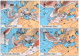
One of the multiple approaches currently explored to mitigate the effects of hydro-meteorological hazardous events aims at improving the numerical weather forecasts. Under an ever increasing societal demand for cost cuts and more precise forecasts, targeted observations are currently receiving great attention within the operational weather community. The MEDEX project (http://medex.inm.uib.es) is aimed at improving the forecasts of high impact weather (HIW) in the Mediterranean and, in particular, proposes the creation of a climatology of sensitivities of such episodes. The construction of a comprehensive climatology of sensitivities is hampered by the lack of an exhaustive collection of Mediterranean HIW events.
In this study we contribute with a systematic climatology of Mediterranean intense cyclones. We perform an objective cluster analysis of intense cyclones detected from the ECMWF ERA40 reanalysis using a k-means algorithm and compute the sensitivities for each of the resulting classes. For each cluster, a representative sensitivity field is computed using the MM5 Adjoint Modeling system. The results show that although the sensitive areas for intense Mediterranean cyclones are not particularly confined, it is remarkable how areas poorly sampled by the regular observing networks, such as North Africa, the Mediterranean Sea and the eastern North-Atlantic, are highlighted in the prototype sensitivity maps.
Citation:
2007. Impact of the lateral boundary conditions resolution on dynamical downscaling of precipitation in mediterranean spain
Amengual, A., Romero, R., Homar, V., Ramis, C., and Alonso, S.
Clim. Dyn., 29, 487-499
IF: 3.961 - Q1
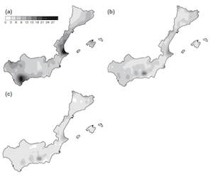
Conclusions on the General Circulation Models (GCMs) horizontal and temporal optimum resolution for dynamical downscaling of rainfall in Mediterranean Spain are derived based on the statistical analysis of mesoscale simulations of past events. These events correspond to the 165 heavy rainfall days during 1984–1993, which are simulated with the HIRLAM mesoscale model. The model is nested within the European Centre for Medium-Range Weather Forecasts atmospheric grid analyses. We represent the spectrum of GCMs resolutions currently applied in climate change research by using varying horizontal and temporal resolutions of these analyses. Three sets of simulations are designed using input data with 1°, 2° and 3° horizontal resolutions (available at 6 h intervals), and three additional sets are designed using 1° horizontal resolution with less frequent boundary conditions updated every 12, 24 and 48 h. The quality of the daily rainfall forecasts is verified against rain-gauge observations using correlation and root mean square error analysis as well as Relative Operating Characteristic curves. Spatial distribution of average precipitation fields are also computed and verified against observations. For the whole Mediterranean Spain, model skill is not appreciably improved when using enhanced spatial input data, suggesting that there is no clear benefit in using high resolution data from General Circulation Model for the regional downscaling of precipitation under the conditions tested. However, significant differences are found in verification scores when boundary conditions are interpolated less frequently than 12 h apart. The analysis is particularized for six major rain bearing flow regimes that affect the region, and differences in model performance are found among the flow types, with slightly better forecasts for Atlantic and cold front passage flows. A remarkable spatial variability in forecast quality is found in the domain, with an overall tendency for higher Relative Operating Characteristic scores in the west and north of the region and over highlands, where the two previous flow regimes are quite influential. The findings of this study could be of help for dynamical downscaling design applied to future precipitation scenarios in the region, as well as to better establish confidence intervals on its results.
Citation:
2007. Sensitivities of a Flash Flood Event over Catalonia: A Numerical Analysis
Martín, A., Romero, R., Homar, V., De Luque, A., Alonso, S., Rigo, T., and Llasat, M.C.
Mon. Weather Rev., 135, 651-669
IF: 2.267 - Q2
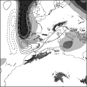
On 9 and 10 June 2000, the northeastern part of the Iberian Peninsula was affected by heavy rains that produced severe floods over densely populated areas. The zones most affected were the provinces of Tarragona and Barcelona, located in the region of Catalonia. Five people were killed, 500 were evacuated, and the property losses were estimated to exceed 65 million euros. The episode was characterized by the entrance of an Atlantic low-level cold front and an upper-level trough that contributed to the generation of a mesoscale cyclone in the Mediterranean Sea east of mainland Spain. The circulation associated with this mesoscale cyclone advected warm and moist air toward Catalonia from the Mediterranean Sea. The convergence zone between the easterly flow and the Atlantic front, as well as the complex orography of the region, are shown to be involved in the triggering and organization of the convective systems. Radar shows the development of two long-lived mesoscale convective systems that merged and remained quasi-stationary nearby the city of Barcelona for nearly 2 h.
The fifth-generation Pennsylvania State University–National Center for Atmospheric Research (PSU– NCAR) Mesoscale Model (MM5) short-range numerical simulations of the episode succeed reasonably well in capturing the accumulated rainfall patterns and important mesoscale aspects of the event. The role of the orography and latent heat release in generating and sustaining the quasi-stationary precipitating systems is assessed through numerical sensitivity analysis. A piecewise potential vorticity inversion technique, assisted by sensitivity fields derived from an adjoint model, provides a test bed to investigate the predictability of the damaging rains given uncertainties in the initial fields. The adjoint results highlight the importance of the details associated with the upper-level precursor trough. Therefore, the effects of small perturbations to the trough intensity and location are also investigated. Interestingly, despite the orography's active role in the generation of the Mediterranean mesoscale cyclone and, hence, on the location of the precipitation maxima, the predictability of the spatial and temporal distribution and amounts of precipitation is shorter than might be expected. This reduced predictability of the rainfall field is attributed to the high sensitivity of the location and depth of the mesoscale cyclone identified in the Mediterranean Sea east of Catalonia to perturbations; that is, to the location and intensity of the precursor upper-level trough, compatible with realistic analysis errors.
Citation:
2006. Value of Human-Generated Perturbations in Short-Range Ensemble Forecasts of Severe Weather
Homar, V., Stensrud, D. J., Levit, J.J., and Bright, D.R.
Weather Forecast., 21, 347-363
IF: 1.055 - Q3
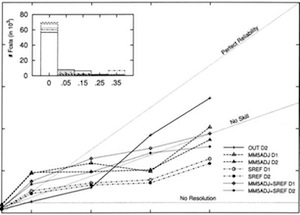
During the spring of 2003, the Storm Prediction Center, in partnership with the National Severe Storms Laboratory, conducted an experiment to explore the value of having operational severe weather forecasters involved in the generation of a short-range ensemble forecasting system. The idea was to create a customized ensemble to provide guidance on the severe weather threat over the following 48 h. The forecaster was asked to highlight structures of interest in the control run and, using an adjoint model, a set of perturbations was obtained and used to generate a 32-member fifth-generation Pennsylvania State University–National Center for Atmospheric Research Mesoscale Model (MM5) ensemble. The performance of this experimental ensemble is objectively evaluated and compared with other available forecasts (both deterministic and ensemble) using real-time severe weather reports and precipitation in the central and eastern parts of the continental United States. The experimental ensemble outperforms the operational forecasts considered in the study for episodes with moderate-to-high probability of severe weather occurrence and those with moderate probability of heavy precipitation. On the other hand, the experimental ensemble forecasts of low-probability severe weather and low precipitation amounts have less skill than the operational models, arguably due to the lack of global dispersion in a system designed to target the spread over specific areas of concern for severe weather. Results from an additional test ensemble constructed by combining automatic and manually perturbed members show the best results for numerical forecasts of severe weather for all probability values. While the value of human contribution in the numerical forecast is demonstrated, further research is needed to determine how to better use the skill and experience of the forecaster in the construction of short-range ensembles.
Citation:
2005. Predictability of prototype flash flood events in the Western Mediterranean under
uncertainties of the precursor upper-level disturbance: The HYDROPTIMET case studies
Romero, R., Martín, A., Homar, V., Alonso, S., and Ramis, C.
Nat. Hazards Earth syst. Sci., 5, 505-525
IF: NA - Q4
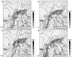
The HYDROPTIMET case studies (9-10 June 2000 Catalogne, 8-9 September 2002 Cevennes and 24-26 November 2002 Piedmont) appear to encompass a sort of prototype flash-flood situations in the western Mediterranean attending to the relevant synoptic and mesoscale signatures identified on the meteorological charts. In Catalogne, the convective event was driven by a low-pressure system of relatively small dimensions developed over the mediterranean coast of Spain that moved into southern France. For Cevennes, the main circulation pattern was a synoptic-scale Atlantic low which induced a persistent southerly low-level jet (LLJ) over the western Mediterranean, strengthened by the Alps along its western flank, which guaranteed continuous moisture supply towards southern France where the long-lived, quasistationary convective system developed. The long Piedmont episode, very representative of the most severe alpine flash flood events, shares some similarities with the Cevennes situation during its first stage in that it was controlled by a southerly moist LLJ associated with a large-scale disturbance located to the west. However, these circulation features were transient aspects and during the second half of the episode the situation was dominated by a cyclogenesis process over the Mediterranean which gave place to a mesoscale-size depression at surface that acted to force new heavy rain over the slopes of the Alps and maritime areas. That is, the Piedmont episode can be catalogued as of mixed type with regard to the responsible surface disturbance, evolving from a large-scale pattern with remote action (like Cevennes) to a mesoscale pattern with local action (like Catalogne). A prominent mid-tropospheric trough or cut-off low can be identified in all events prior and during the period of heavy rain, which clearly served as the precursor agent for the onset of the flash-flood conditions and the cyclogenesis at low levels. Being aware of the uncertainty in the representation of the upper-level disturbance and the necessity to cope with it within the operational context when attempting to issue short to mid-range numerical weather predictions of these high impact weather events, a systematic exploration of the predictability of the three selected case studies subject to uncertainties in the representation of the upper-level precursor disturbance is carried out in this paper. The study is based on an ensemble of mesoscale numerical simulations of each event with the MM5 non-hydrostatic model after perturbing in a systematic way the upper-level disturbance, in the sense of displacing slightly this disturbance upstream/downstream along the zonal direction and intensifying/weakening its amplitude. These perturbations are guided by a previous application of the MM5-adjoint model, which consistently shows high sensitivities of the dynamical control of the heavy rain to the low configuration about the upper-level disturbance on the day before, thus confirming the precursor characteristics of this agent. The perturbations are introduced to the initial conditions by applying a potential vorticity (PV) inversion procedure to the positive PV anomaly associated with the upper-level disturbance, and then using the inverted ?elds (wind, temperature and geopotential) to modify under a physically consistent balance the model initial ?elds. The results generally show that the events dominated by mesoscale low-level disturbances (Catalogne and last stage of the Piedmont episode) are very sensitive to the initial uncertainties, such that the heavy rain location and magnitude are in some of the experiments strongly changed in response to the "forecast errors" of the cyclone trajectory, intensity, shape and translational speed. In contrast, the other situations (Cevennes and initial stage of the Piedmont episode), dominated by a larger scale system wich basically acts to guarantee the establishment and persistence of the southerly LLJ towards the southern France-north Italy orography, exhibit much higher predictability. That is, the slight modifications in the LLJ direction and intensity encompassed by the ensemble of perturbed forecasts are less critical with respect to the heavy precipitation potential and affected area.
Citation:
2004. Sensitivities of an intense Mediterranean cyclone: analysis and validation
Homar, V. and D. J Stensrud
Quart. J. R. Meteorol. Soc., 130, 2619-2540
IF: 1.844 - Q2
![Figure 5. Vertical averages of the absolute values of the sensitivities to the response function J1 for all fields, for simulation runs of different durations ending at the sensitivity time (0000 UTC 11 November): (a) 12 h; (b) 24 h; (c) 36 h, and (d) 48 h. Units of the field are non-physical (s-1 /[model input]). Contour intervals are two units, with the lowest, outermost, contour being +2. In panel (a), the stippled square shows the location of the 600 x 600 km2 horizontal extent of J1 around the centre of the cyclone in the control simulation.
Sensitivities of an intense Mediterranean cyclone: analysis and validation](imatges/sci_papers/2004-homar_et_stensrud.png)
On 10 and 11 November 2001 a deep cyclone moved northward across the western Mediterranean. Severe floods affected Algeria on 10 November and a mesoscale-sized region of strong damaging winds occurred over the Balearics and eastern Spain during the first hours of 11 November. These large intense cyclones, originating over north Africa and moving northward, are occasionally observed in the region. Numerical simulations of these types of events are potentially hampered by the lack of observations over the Mediterranean Sea, north Africa and the Atlantic Ocean. To evaluate more accurately the regions in which the model simulations are influenced by this lack of data, the MM5 adjoint system is used to determine the most sensitive areas within the initial conditions of the simulation of this 10-11 November event. Limitations of available adjoint models, such as their linear character, suggest that a test of the applicability of MM5 to the case under analysis is needed. In this study, the evaluation is performed by means of the tangent linear model and, despite finding that the adjoint has an acceptable accuracy, important nonlinear effects are found and attributed to the moist processes. The study tracks backward in time the sensitivities shown at different simulation times using parameters chosen to characterize the cyclone's intensity at 0000 UTC 11 November. Results reveal that the areas that show the largest sensitivities are located over north Africa for the 12 h and 24 h simulations, whereas south-western and western Europe emerge as areas with important sensitivities for the longer 36 h and 48 h simulations. Subsynoptic details regarding the shape and intensity of an upper-level trough, as well as a low-level cold front, are highlighted by the adjoint runs as the structures which influence most strongly the baroclinic development of the intense Mediterranean cyclone and the damaging surface winds it produces. The usefulness of the sensitivity fields in the nonlinear simulations is confirmed by perturbing the control model's initial conditions using the adjoint results as guidance. This analysis helps to quantify the limitations of the linear estimation when applied to the full nonlinear model, focusing on the nonlinearities introduced by the moist physics parametrizations.
Citation:
2003. Tornadoes over complex terrain: An analysis of the 28th August 1999 tornadic event in eastern Spain
Homar, V., Gayà, M., Romero, R., Ramis, C., and Alonso, S.
Atmos. Res., 67-68, 301-317
IF: 1.012 - Q3
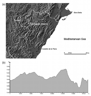
On 28 August 1999, a tornadic storm developed during the afternoon over the Gudar range, near the border between Teruel and Castellon provinces (Sistema Iberico, eastern Spain). The area has a characteristic complex terrain with peaks up to 2000 m. At least one tornado developed, which attained F3 intensity, producing severe damage in the forest that covers the mountains. The region is well known as a summer convective storm nest and, not surprisingly, a range in the Sistema Iberico is called Sierra del Rayo (lightning range). The meteorological situation on 28 August 1999 shows the presence of a thermal low over the Iberian peninsula, producing warm and moist air advection towards inland Castellon at low levels. Meanwhile, a cold trough crossed the Iberian Peninsula from west to east at upper levels. Deep convection is identified on the Meteosat images during the afternoon, when the upper level trough reached the area where warm and humid Mediterranean air was concentrated. The radar images reveal signals indicating the supercellular character of the tornado-producing storm. Weak echo region, frontal and rear inflow notches are identified on the low-level CAPPIs images. In order to study the roles of the orography and the solar radiation on the ingredients associated with the tornadic storm development, numerical simulations of the event were performed, using the non-hydrostatic MM5 model. Very fine grid resolution, up to 2 km in the horizontal, allows us to determine the role of the complex terrain in favoring environmental conditions associated with the onset of severe convection. In fact, interaction of certain low-level flows with particular topographic features with scales of about 20 to 50 km is found to generate intense small-scale circulations over the storm nesting region. A more detailed analysis of the orographic effect shows that fine scale terrain features (2 - 5 km) are responsible for the intensification of the convective storms, whereas modification of the low-level flow by the large-scale features (20 - 50 km) is able to trigger the convective systems. The effect of the solar-induced surface heating is also analyzed and it turns to be crucial not only by intensifying the Iberian thermal low and the easterly warm and moist air advection towards the area but also by promoting mountain breezes.
Citation:
2003. An estimate of the effects of climate change on the rainfall of Mediterranean Spain
by the late 21st century
Sumner, G., Romero, R., Homar, V., Ramis, C., Alonso, S., and Zorita, E.
Climate Dyn., 20, 789-605
IF: 3.437 - Q1
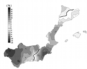
The study uses a GCM (ECHAM-OPYC3) and the association between the atmospheric circulation at 925 and 500 hPa and the distribution of daily precipitation for Mediterranean Spain (from earlier analyses) to give estimates of the probable annual precipitation for the late twenty first century. A downscaling technique is used which involves the matching of daily circulation output from the model for a sequence of years in the late twentieth century (1971-90) and for a corresponding period in the late twenty first century (2080-99) to derive probable regional atmospheric pattern (AP) frequencies for this latter period, and thence to estimate likely changes in annual precipitation. Model days are classified by searching for the closest analogue amongst 19 previously identified APs from an earlier study. Future annual precipitation distribution is derived using previously established relationships between circulation type and daily precipitation distribution. Predicted AP frequencies and pecipitation amounts and distribution are compensated by comparing model output with ECMWF data for a decade (1984-93) within the 1971-90 sequence, so that the analysis also provides a verification of the performance of the model. In general the agreement between model output and actual AP frequencies is very good for the present day, though for this southerly region the model appears slightly to underestimate the frequency of easterly type circulations, many of which yield some of the most significant autumn severe storm rainfalls along the Mediterranean coast. The model tends to overestimate the frequency of westerly type situations. The study utilises a "moving window" technique in an attempt to derive measures of interdecadal variability within the two 20 year periods. This avoids use of data from outside the periods, which would incorporate changing AP frequencies during a period of sustained climate change. Quite pronounced changes in frequency are indicated for certain APs. Marked decreases in frequency are indicated for many near-surface circulations with a westerly or northerly component. For APs with an easterly component, some are shown to increase, others to decrease. Increases in inter-decadal variability are strongly indicated for most APs, though for some easterly situations there is no clear signal. A significant annual precipitation reduction of between 6 to 14% is indicated for Andalucia and the upland parts of Catalunya. In contrast, there is an increase in annual totals of up to 14% along parts of the coast between Almeria and the French border.
Citation:
2003. Numerical diagnosis of a small, quasi-tropical cyclone over the Western
Mediterranean: Dynamical vs. boundary factors
Homar, V., Romero, R., Stensrud, D.J., Ramis, C., Alonso, S.
Quart. J. R. Meteorol. Soc., 129, 1469-1490
IF: 2.117 - Q2
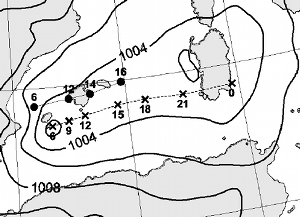
A small, quasi-tropical cyclone occurred on 12 September 1996 over the western Mediterranean. Intense convective activity over the region during this period also produced a tornado outbreak in the Balearic Islands and torrential precipitation over eastern mainland Spain. Mesoscale model runs properly simulate the cyclone formation and show convection and heavy precipitation following the cyclone trajectory during its eastward progression. A sensitivity study examining the upper-level dynamic forcing, latent-and sensible-heat fluxes from the sea, and orography is conducted. A potential-vorticity (PV) inversion technique is used to reduce the amplitude of the upper-level trough in the model initial conditions. The results show that neither the orography nor the sensible-heat ux from the sea play a signi cant role during this particular cyclone development. Conversely, both the latent-heat ux and the upper-level trough are shown to be crucial for low-level cyclogenesis. Features common to hurricane-like polar lows are found for the cyclone, and an analysis of the precise role of the upper-level structures and the convective development is conducted. A factor-separation technique is used to determine the individual effects of the aforementioned factors, as well as their interaction. At the rst stage of the cyclogenesis, the upper-level PV anomaly enhanced the low-level circulation of the synoptic-scale low and enhanced the latent-heat ux from the sea. During its mature stage, the circulation associated with the small-scale cyclone enhanced the latent-heat ux from the sea, thereby helping to maintain the development of deep convection, and inducing further cyclone deepening by diabatic heating. This scenario has many similarities with the air-sea interaction instability mechanism. Thus, the joint action of the upper-level anomaly, as a spin-up agent, and the latent-heat ux, as a sustainer of convection, emerges as the primary factor for the genesis and evolution of the small quasi-tropical cyclone.
Citation:
2003. Role of orography in the spatial distribution of precipitation over the Spanish
Mediterranean zone
García, M., Ramis, C., Romero, R., Alonso., S, and Homar, V.
Climate Res., 23, 247-261
IF: 1.159 - Q2

The effects of orography on the precipitation field in the Spanish Mediterranean zone are studied through numerical simulations from a climatological point of view. The main atmospheric patterns that produce significant precipitation in the considered area, derived in a previous study, have been used as input data. The numerical simulations have been performed using the HIRLAM model. We isolate, by means of a factor-separation technique, the separate effects of the Iberian and non-Iberian orographies, as well as the synergy between the 2 orographies. The diversity of simulated precipitation spatial distributions is clearly linked to the wide variety of flows over the Iberian Peninsula. However, a clear distinction between Atlantic and western Mediterranean disturbances is obtained. When Atlantic westerlies occur over the Iberian Peninsula, rainfall in the Spanish Mediterranean zone is enhanced by orography, mainly by that of Iberia. Otherwise, when the Iberian Peninsula is affected by Mediterranean disturbances, local orographic enhancements along with the redistribution of precipitation due to non-Iberian orography and synergistic effects are observed. The North African Atlas range, due to its primary influence, emerges as one of the factors governing the spatial distribution of rainfall across the Spanish Mediterranean zone.
Citation:
2002. Numerical study of the October 2000 torrential precipitation event over eastern
Spain: Analysis of the synoptic-scale stationarity
Homar, V., Romero, R., Ramis, C., and Alonso, S.
Ann. Geophys., 20, 2047-2066
IF: 1.189 - Q2
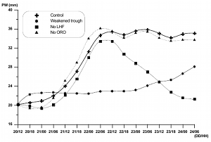
A torrential precipitation event affected eastern Spain during 21 to 24 October 2000. Total accumulated rainfall higher than 500 mm was registered at some locations, with values up to 300 mm in a 24-h period. The synoptic-scale charts for these days show the presence of a cold cut-off low aloft, south of the Iberian Peninsula, as a part of an -blocking structure over Europe. At low levels, persistent easterly winds, established between a dominant anticyclone over eastern Europe and a cyclone over Morocco, are found over the western Mediterranean throughout the entire period. Satellite images show the advance and breaking away of a trough, with an associated cold front, over the Iberian Peninsula, which resulted in the cutoff low formation. Later, scattered convective cells are detected along the eastern Spanish coast during more than 3 days. Numerical simulations reveal that the convective environment was developed by the low-level advection of warm and moist air from central Mediterranean, being charged of moisture by evaporation from the sea. Sensitivity runs confirm that the synoptic-scale persistent low-level easterly flow, and specifically, the presence of a low level jet, was crucial for the subsynoptic processes leading to the long lasting torrential rainfall over the exposed terrains of eastern Spain. The stagnancy of the low-level flow is attributed to the quasi-stationary characteristics of the upper level cutoff low located south of the Iberian Peninsula. Experiments with modified upper-level potential vorticity distributions reveal that slight deviations from the observed configuration result in enhanced mobility of the low-level flow pattern, and thereby a reduction of the precipitation persistence. This suggests the major importance of a correct representation in the model initial conditions of the intensity and location of the upper level features, in order to obtain valuable numerical forecasts of these heavy rainfall events.
Citation:
2002. The paradoxical increase of Mediterranean extreme daily rainfall in spite of
decrease in total values
Alpert, P., Ben-Gai, T., Baharad, A., Benjamini, Y., Yekutieli, D., Colacino, M., Diodato, L., Ramis, C., Homar, V., Romero, R., Michaelides, S., and Manes, A.
Geophys. Res. Lett. 29, 11, 31-1 -- 31-4
IF: 2.150 - Q1
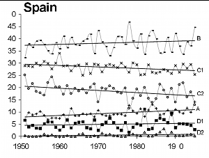
Earlier reports indicated some specific isolated regions exhibiting a paradoxical increase of extreme rainfall in spite of decrease in the totals. Here, we conduct a coherent study of the full-scale of daily rainfall categories over a relatively large subtropical region -the Mediterranean- in order to assess whether this paradoxical behavior is real and its extent. We show that the torrential rainfall in Italy exceeding 128 mm/d has increased percentage-wise by a factor of 4 during 1951-1995 with strong peaks in El-Nino years. In Spain, extreme categories at both tails of the distribution (light: 0-4 mm/d and heavy/torrential: 64 mm/d and up) increased significantly. No significant trends were found in Israel and Cyprus. The consequent redistribution of the daily rainfall categories -torrential/heavy against the moderate/light intensities- is of utmost interest particularly in the semi-arid sub-tropical regions for purposes of water management, soil erosion and flash floods impacts.
Citation:
2002. A deep cyclone of African origin over the Western Mediterranean: Diagnosis and
Numerical Simulation
Homar, V., Ramis, C., and Alonso, S.
Ann. Geophys. 20, 93-2106
IF: 1.189 - Q2
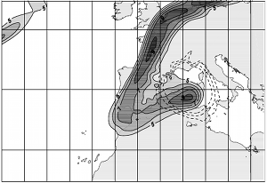
From 19 to 22 December 1979, a deep cyclone evolved over the Western Mediterranean. Gusty winds of more than 30 m/s, as well as a strong pressure decrease to about 990 hPa were recorded in Palma de Mallorca (Balearic Islands, Spain). ECMWF analyses are used for a diagnosis and numerical study of the case. Sensitivity experiments using the HIRLAM model are performed to assess the role of the surface sensible heat flux, latent heat release and orography on the genesis and evolution of the cyclone. At synoptic scale, the situation is governed by the instability of an upper-level short wave. The cyclone developed within a notable baroclinic environment, which resulted from a cold advection from the northwest towards North Africa. The baroclinicity at first stages of the cyclogenesis is quantified by means of the Eady model. At latter stages, the evolution of the potential vorticity structures at high levels reveals a wide tropopause fold over the cyclone, as well as the presence of a strong anomaly associated with the low-level system. Sensitivity experiments reveal a notable cyclogenetic role of the latent heat release throughout the atmosphere in the deepening of the low, whereas no significant effect of the surface sensible heat flux is obtained for the simulation interval. On the other hand, an unusual cyclolytic role can be attributed to the northern ranges of the Mediterranean basin. Effectively, the low enlargement and deepening is constrained by a "wall effect", which is a consequence of the interaction of the cyclonic flow and those northern mountainous systems.
Citation:
2001. Tornadoes and waterspouts in the Balearic Islands: Phenomena and environment
characterization
Gayà, M., Homar, V., Romero, R., and Ramis, C.
Atmos. Research. 56, 253-267
IF: 0.936 - Q3
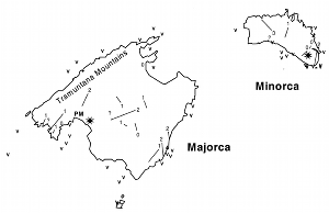
In the Balearic Islands, located in the Western Mediterranean, 27 tornadoes and 54 waterspouts have been recorded during the period 1989-1999. A climatology focusing, which focuses on path length, F-scale velocity, season and time of occurrence, is presented. September and October appear to be the months with the highest frequency of appearance. The environment in which thunderstorm producing tornadoes and waterspouts developed has been analysed. Main thermodynamic stability indices reveal that no specific conditions are required for the tornado and waterspout genesis. It is also found that these events form in air masses colder than that indicated by the climatology of the region. Analyses of helicity and CAPE demonstrate that, in most of the cases, the environments were not favourable for mesocyclone formation and supercell development.
Citation:
2001. A synoptic and mesoscale diagnosis of a tornado outbreak in the Balearic Islands
Homar, V., Gayà, M., and Ramis, C.
Atmos. Research. 56, 31-55
IF: 0.936 - Q3
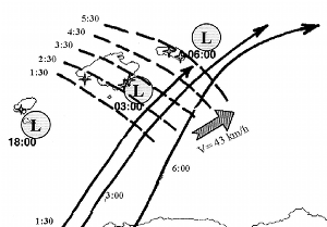
A tornadic event occurred over the Balearic Islands (Western Mediterranean) during the evening of 11 September 1996 and the following night. A total of six tornadoes were observed, affecting populated areas, with an economical damage of more than 6 million euro. The meteorological situation in which severe weather developed was characterised at low levels by a low covering all the Western Mediterranean with well-marked warm advection towards the Balearic Islands. At mid and upper levels, a low was located to the southwest of the Iberian peninsula, producing southwesterly winds over the region. Satellite imagery shows that the first tornado, observed over the Ibiza Island, was produced by a mature thunderstorm, which presented a well-defined V-shape on the IR images. Tornadoes occurring in Majorca and Minorca islands were produced by convective systems, which were in their initial development state. Most of these tornadogenetic convective systems developed over a low-level convergence line formed as a consequence of the existence of a low moving northeastwards along the south of the Balearics and a very small and deep cyclone formed offshore in front of the Valencia coast. Positive interaction between the low-level convergence line and an upper-level jet streak for producing the lift of low-level parcels has also been identified.
Citation:
2001. Precipitation seasonality in eastern and southern coastal Spain
Sumner, G. N, Homar, V., and Ramis, C.
Int. J. Climatol. 21, 219-247
IF: 1.492 - Q2

The nature of the seasonality of precipitation in eastern and southern coastal Spain (including both the Mediterranean and the far southwestern Atlantic provinces) is examined using monthly precipitation values available for 410 sites for the period 1964-1993. Important contrasts are illustrated between eastern (Mediterranean) and southern (Atlantic) areas. In the east, seasonality is more subdued due to incursions of fronts from the north at all times of the year. In the far south, the months of July and August are almost completely dry, but the period October-February is wet due to incursions of active Atlantic frontal systems. In central areas (Almería, Murcia, Alacant, Valencia and the Illes Balears) the significance of extensive severe thunderstorm development during September and October produces an autumn peak in precipitation amount. The spatial variation of precipitation seasonality is further examined using the seasonality index derived by Walsh and Lawler (Walsh PD, Lawler DM. 1981. Rainfall seasonality: description, spatial patterns and change through time. Weather 36: 201-208). Trends of this index through the 30-year period are identified for some areas using linear regression on 5-year running means of the index, and indicate that seasonality is increasing in the south (Andalucía), around the uplands of Catalunya (near Lleida) in the east, and in a few smaller areas in between. In the south, the increase in seasonality is due to a greater concentration of precipitation during the cooler part of the year, so that the period January-March is becoming drier, but October-December, wetter. The overall cool season precipitation remains much as for the present, though some evidence for drying is indicated for Malaga, Jaen and Granada. Precipitation in the normally dry month of July is also increasing. In upland Catalunya, there are indications of a greater concentration of cool season precipitation, with, notably, higher amounts in October and some evidence of warm season drying, notably in June.
Citation:
1999. A Case of Convection Development over Western Mediterranean Sea: A study
through Numerical Simulations
Homar, V., Romero, R., Ramis, C., Alonso, S., Alcorcón, M., and García-Moya, J.A.
Meteorol. Atmos. Phys. 71, 169-188
IF: 0.574 - Q4
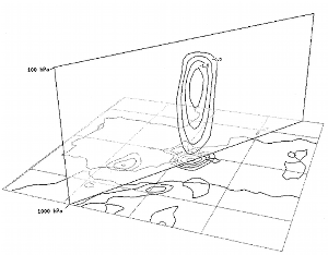
A convective case producing heavy precipitation in the western Mediterranean region, characterized by pronounced upper level forcing and main rainfall over the sea, is studied. On the day of the event (September 28th, 1994), more than 140mm of precipitation were recorded in coastal lands of eastern Spain, and 180mm were estimated over the sea with radar data. Synoptically, the case appears to combine warm and moist easterly advection at low levels, typically observed in torrential rainfall events of the region, with a less common strong upper level dynamical forcing. A set of mesoscale numerical simulations using the Hirlam model is performed to investigate the mechanisms responsible for the convection development, and to assess the influence of the orography on the rainfall field. Model output diagnosis indicates that in addition to the lower level forcing, a two-jets interaction is decisive for the triggering and driving of the convection during the event. Moreover, a non-topographic simulation reveals a relatively weak influence of the orography on this event when compared with other similar heavy precipitation cases in eastern Spain. Previous studies have shown an orographic influence of more than 90% on the rainfall whereas in this case about 50% of the precipitation over the area is attributed to the orographic forcing. The study is extended with an analysis of the individual effects of the Atlas and Iberian Peninsula, by means of a factor separation technique. It is shown that the Atlas range induces a redistribution of the precipitation over the Mediterranean, whereas local enhancements can be attributed to the Iberian topography.
Citation:
1998. Diagnosis and Numerical Simulation of a Torrential Precipitation Event in Catalonia (Spain)
Ramis, C., Romero, R., Homar, V., Alonso, S., and Alarcón, M.
Meteorol. Atmos. Phys. 69, 1-21
IF: 0.737 - Q4
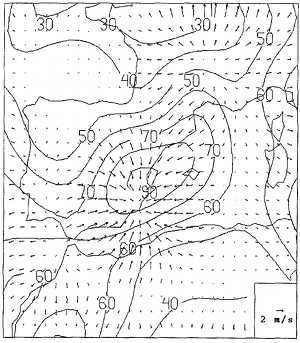
A torrential precipitation event occurred in Catalonia (northeastern part of Spain) during 9 and 10 October 1994. More than 400mm were registered in the south of Catalonia. A diagnostic study shows that most of the ingredients to produce heavy rain (large scale upward vertical motion, instability, high moisture content in all the troposphere) were present over the Spanish coast and western Mediterranean. Mesoscale triggering mechanisms have been associated with the orographic forcing, not only through physical lifting of moist air by the coastal mountains, but also by the redistribution of the surface pressure field induced by the Atlas and Pyrenees ranges. A numerical simulation of the event using a meso-/3 model has been performed. The model forecasts qualitatively well the rainfall distribution but underestimates the maximum rainfalls. The effects of the orography and the evaporation from the sea have been also studied. The simulations have shown that the action of the orography is decisive for the rainfall, pressure and wind distributions over the Spanish coast and the western Mediterranean. The isolated action of the evaporation turns to be much less important. However the combined effect of orography and evaporation is the most important factor in the areas where the greatest amount of rainfall occurred.
Citation:


![Figure 5. Vertical averages of the absolute values of the sensitivities to the response function J1 for all fields, for simulation runs of different durations ending at the sensitivity time (0000 UTC 11 November): (a) 12 h; (b) 24 h; (c) 36 h, and (d) 48 h. Units of the field are non-physical (s-1 /[model input]). Contour intervals are two units, with the lowest, outermost, contour being +2. In panel (a), the stippled square shows the location of the 600 x 600 km2 horizontal extent of J1 around the centre of the cyclone in the control simulation.
Sensitivities of an intense Mediterranean cyclone: analysis and validation](imatges/sci_papers/2004-homar_et_stensrud.png)


